



| HEADLINE |

|

Nepal Glacier Collapse and Flash Flood: Our Perspective
Published : Tuesday, 1 September, 2026 at 12:00 AM
M A Halim


 Last Wednesday, a catastrophic glacier collapse and flash flood struck along the Nepal-Tibet border, causing devastation beyond measure. As of now (31 August morning), official reports recorded 797 deaths and 2,502 missing persons. The numbers of dead, injured, and missing continue to rise daily, so the full extent of the disaster will only be known later. Initial estimates suggest that recovery will require at least USD 5 billion, though the loss of human lives and families cannot be quantified in monetary terms.
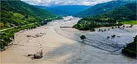
According to preliminary USGS data, a 5.2 magnitude earthquake in the Himalayas was cited as the trigger. Later geological analysis revealed that a glacier of about 500,000 cubic meters collapsed from LangtaNirung peak (5.2km above sea level) into a valley 1.2km below. This generated a torrent of debris, mud, rocks, and ice that surged down the Bhote Koshi River, devastating settlements, infrastructure, and villages across 100km in Basua, Nuwakot, and Dhading districts. The flow speed was estimated at 192km per hour. Roads, bridges, schools, homes, businesses, and even hydropower plants were destroyed. Tourists from 35 countries in the Kailash-Manasarovar region were also among the dead and missing.
Nepal is often considered a pioneer in disaster management in South Asia, with institutional structures from national to village levels, trained local volunteers, and strong local governance. During the 2015 Gorkha earthquake recovery, Nepal initially welcomed foreign experts but later relied solely on its own capacity. Under the Disaster Risk Reduction and Management Act 2017, the National Disaster Management Authority (NDMA) has broad powers for decision-making and coordination. While international solidarity is customary, Nepal initially rejected foreign assistance in this disaster, only agreeing later under pressure from countries whose citizens were missing. This shows that no matter how strong preparedness may be, nature always finds new ways to challenge human capacity.
The exact causes of the glacier collapse will take time to analyze. Nepal has accused China of failing to provide timely warnings, while China insists the event occurred within Nepal’s territory. Climate change and Himalayan ice melt are also cited as contributing factors. Research had already warned in 2019 of glacier collapses leading to flash floods. Future studies will clarify the causes, early warning signals, and lessons for preparedness.
Nepal’s Disaster and Bangladesh’s Context
Floodwaters from Nepal have already reached Bihar’s Gandak River in India, and may flow through West Bengal’s Farakka into Bangladesh’s Padma River. While the intensity is expected to diminish, Bangladesh must remain vigilant. Past experience shows surprises: the 2025 Feni flash flood happened without warning. Considering my personal experience in 1999, Gomti embankment breach also happened without warning.
Bangladesh lacks towering Himalayan peaks, but it does have ranges like Keokradong in Bandarban and the vast Kaptai Lake (688km²) surrounded by hills. Surveys conducted here have mainly focused on hazard maps, landslide risks, and resource availability. To my knowledge, no geological survey has been done to identify fault lines in these mountains and lakes. Even without being a geologist, I suspect such faults might exist, as landslides are a recurring phenomenon. Some notable landslide disasters include: 2007 (Chattogram) 127 deaths, 2012 (Bandarban & Cox’s Bazar) 110 deaths, 2017 (Chattogram, Cox’s Bazar, Bandarban & Rangamati) 160 deaths, 2026 (Bandarban, Rangamati & Cox’s Bazar, including 16 Rohingya refugees) 44 deaths. Thus, geological surveys must go beyond hazard maps to include: Geographic and internal structural data, Risk awareness and preparedness, Assessment of local capacity, Development planning, including tourism safety and promotion.
The Kaptai Dam (built in 1962) and its hydroelectric plant also need reassessment in today’s context. If a Nepal-like disaster struck, the 55,000 people living around the lake, along with tourism and infrastructure, could face severe losses.
Disasters halt livelihoods as well as damage infrastructure. Learning from Nepal, Bangladesh must conduct comprehensive geological surveys of all hill regions, identify risks, and communicate them to vulnerable communities. Bangladesh has institutional disaster management committees from national to ward level, but questions remain about their effectiveness, empowerment, and budget allocations. The Standing Orders on Disaster (SOD) 2019 are under revision; these issues should be addressed in the revised version.
Finally, just as cyclone warnings save lives, Bangladesh should develop early warning systems for landslides. A striking example comes from Nepal: when a school principal received word that floodwaters were rushing toward his school, he immediately dismissed classes, saving 1,643 students. Timely warnings can indeed save lives.
The writer is a former Director of Bangladesh Red Crescent Society and an analyst on disaster and humanitarian issues
Loading...
Loading...
Also read



Editor : Iqbal Sobhan Chowdhury
Published by the Editor on behalf of the Observer Ltd. from Globe Printers, 24/A, New Eskaton Road, Ramna, Dhaka.
Editorial, News and Commercial Offices : Aziz Bhaban (2nd floor), 93, Motijheel C/A, Dhaka-1000.
Phone: PABX- 41053001-06; Advertisement: 41053012; 01793317829, 01550707291, E-mail: [email protected], [email protected] Online: email: [email protected] 41053014; 01550707297 Advertisement: 01550707296
Published by the Editor on behalf of the Observer Ltd. from Globe Printers, 24/A, New Eskaton Road, Ramna, Dhaka.
Editorial, News and Commercial Offices : Aziz Bhaban (2nd floor), 93, Motijheel C/A, Dhaka-1000.
Phone: PABX- 41053001-06; Advertisement: 41053012; 01793317829, 01550707291, E-mail: [email protected], [email protected] Online: email: [email protected] 41053014; 01550707297 Advertisement: 01550707296


