



| HEADLINE |

|

Bandarban isolated as Sangu, Matamuhuri overflow
Published : Friday, 10 July, 2026 at 1:18 PM
Observer Online Report


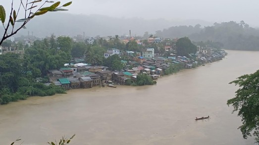
Continuous heavy rainfall has pushed the Sangu and Matamuhuri rivers above the danger level, triggering floods, landslides and widespread disruption across Bandarban district.
Road communication with Chattogram, Cox's Bazar and Rangamati has been severed after floodwaters inundated key roads, forcing the suspension of bus services. Hundreds of passengers were left stranded at bus terminals, while some resorted to travelling short distances in smaller vehicles at higher fares.
The district headquarters, Lama, Alikadam, Rowangchhari and Naikhongchhari are among the worst-affected areas, with floodwaters inundating low-lying neighbourhoods.
According to the Bangladesh Water Development Board, as of 9:00am on Friday, the Sangu River was flowing at 15.75 metres and the Matamuhuri River at 12.27 metres, both above their respective danger levels.
The Bangladesh Meteorological Department recorded 131mm of rainfall in Bandarban in the 24 hours ending at 6:00am on Friday.
Flooding has affected several riverside areas of the district headquarters, including Balaghata, Kamlong, Army Para, Islampur and Sher-e-Bangla Nagar, prompting many residents to move to emergency shelters.
The Public Health Engineering Department has deployed a mobile water purification unit to supply safe drinking water to flood-affected residents.
Bandarban Hill District Council Chairman Professor Thanjama Lusai inaugurated the initiative at Bandarban Bazar on Thursday.
Deputy Commissioner Md Saniul Ferdous said 220 shelters had been opened across the district's seven upazilas, where around 4,000 people have taken refuge.
Landslides have also disrupted road links, while intermittent power outages and mobile network failures have hampered communication, leaving many residents unable to contact their families.
Loading...
Loading...
Also read







Editor : Iqbal Sobhan Chowdhury
Published by the Editor on behalf of the Observer Ltd. from Globe Printers, 24/A, New Eskaton Road, Ramna, Dhaka.
Editorial, News and Commercial Offices : Aziz Bhaban (2nd floor), 93, Motijheel C/A, Dhaka-1000.
Phone: PABX- 41053001-06; Advertisement: 41053012; 01793317829, 01550707291, E-mail: [email protected], [email protected] Online: email: [email protected] 41053014; 01550707297 Advertisement: 01550707296
Published by the Editor on behalf of the Observer Ltd. from Globe Printers, 24/A, New Eskaton Road, Ramna, Dhaka.
Editorial, News and Commercial Offices : Aziz Bhaban (2nd floor), 93, Motijheel C/A, Dhaka-1000.
Phone: PABX- 41053001-06; Advertisement: 41053012; 01793317829, 01550707291, E-mail: [email protected], [email protected] Online: email: [email protected] 41053014; 01550707297 Advertisement: 01550707296


